Epic Blog
The View of Nakalilok Bay (home of SAFARI camp)
11.19.12

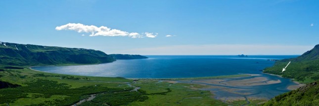
The view of Nakalilok Bay, Alaska. White arrow is location of SAFARI camp. Photo by JohnnyQuiroz.com
So often we show the view from our Alaska Wilderness SAFARI camp, looking across the tidal flat at the dramatic ridges, peaks and mountains of the Aleutian Mountain Range (that you partially see on the left side of this photo). We thought you might find it interesting to actually see Nakalilok Bay itself and the relative location of SAFARI camp to its surroundings (the white arrow in photo).
The tidal flat lies immediately to the left of camp in this photo – it’s the part sand, part shallow clear water area. This is where you will spend the majority of your time fishing for salmon.
The photo also shows about 2 miles of beach you fish on foot, chasing schools of chrome-bright salmon as they’re still cruising the coastline prior to entering streams or estuaries, plus the obvious – the large saltwater bay where you can catch halibut from a small boat on fly or conventional tackle in shallow water (10 to 50 feet).
What you don’t clearly see in the photo is the main river channel, which is the primary area we fish for sea-run dolly varden.
(Photo taken from the summit of Harley Hill, the rounded hill to the right of the snow-capped mountain in the view from camp.)
Posted in All Posts, Photo, SAFARI

